After a 25 year reunion with the Big Pine Forest Service road destiny takes a hand. And a knee.
I traveled to Ojai on May 11, 2013 for a ten day stay with a primary mission other than seeking adventure in my role as the Los Padres Expatriate. As my schedule began to take shape, it became clear I would have one day sufficiently free to contemplate a foray into the Southern Los Padres. Assuming my contemplative process will produce practical ideas is historically dangerous but I was willing to take the chance.
What to do, with just one day, what to do? For inspiration I turned to my library of Southern Los Padres hiking guides.

Pictured above: Hiking the Santa Barbara Backcountry, 1974; Exploring the Santa Barbara Backcountry, 1981; Hike the Santa Barbara Backcountry, 1986 and 1990, Dennis R. Gagnon. Hiking and Backpacking Santa Barbara and Ventura, 2012, Craig R. Carey. The high point of my Southern Los Padres hiking career was the small contribution I was privileged to make to Craig R. Carey’s masterwork.
I started browsing the well worn pages of my 1981 edition of Dennis R. Gagnon’s Exploring the Santa Barbara Backcountry. In times past I made numerous annotations in that volume and thought I might find some inspiration there. A note on page 106 caused the gears in my head to commence grinding.

Exploring the Santa Barbara Backcountry, Dennis R. Gagnon, 1981, page 106
I have some history with bicycles. The first bike I rode seriously was a Peugeot UO8 purchased in 1970 from Sproul’s Bike Shop, which, if I recall correctly, was in downtown Oxnard across the street from the Vogue Theater. I saw The Incredible Mr. Limpet in that movie house when it was first released in 1964. I still love that film, Don Knott’s finest, along with, perhaps, The Ghost and Mr. Chicken. I remember the Peugeot had a Bernard Thevenet signature flag on the left brake cable. In 1984 I bought one of the early production mountain bikes, the Diamondback Ridge Runner, from Bill’s Bike shop in Camarillo, California. My road bike at the time was a Peugot PSV 10 purchased from Channel Islands bicycle in Oxnard. Stan, the proprietor of Channel Islands Bicycle, also hand built beautiful custom frames, but those were out of my price range. The Peugeot, with its odd Helicomatic freewheel, Simplex components and Supervitus 980 butted and brazed frame, came in at less than half the price of the least expensive Campagnolo-equipped Italian super bikes but was, as far as I could tell, as light and responsive. Both the Peugeot and the Diamondback fit me perfectly for their road and off-road purposes and I spent many hours covering many miles on those machines. I cycled on weekdays and hiked weekends and avoided responsibility every day.

1984 Diamond Back Ridge Runner on the Sisar Canyon / Nordhoff Ridge Fire Road overlooking Piedra Blanca, Spring, 1985.

Heading out to ride the gravel road to Blodgett Canyon overlook, on my Peugeot hybrid. Hamilton, Montana, Winter, 1994.

The view from Blodgett Canyon overlook, Spring, 1995.

Leaning on Edwin after a long ride, March 18, 2012. These days I ride mostly on the road in Amish country in the Northeast.

Traffic in Amish country, June 29, 2013.
I remember riding my mountain bike that August day in 1986. I parked my car off Highway 33 at the intersection with Forest Service road 9N11 (the Big Pine / Buckhorn fire road) and started the ride from there. It was hot for my mid-morning start, as would not be untypical for that time of year. The short crossing of the Cuyama had not been scraped and was very sandy. Despite the wide, knobby tires the bike fishtailed and broke traction. Once across the Cuyama River I continued on the conjoined Santa Barbara Canyon Road / Forest Service Road 9N11 to the gate in Alamo Canyon and then ascended the 1800 feet over five miles to the junction with the Sierra Madre fire road (32S13). At the intersection, I continued north the short distance to the Judell Canyon Trail. The day got progressively hotter as I ascended which made the knowledge that the return was mostly a downhill run quite welcome. It was close to 100°F when I loaded my bike into the car for the drive back to Ojai.
What has kept this day so clear in memory is not the ride itself but the moment when both my hamstrings cramped at the Ojai Frosty (another lost Ojai tradition). I recall vividly the puzzled stares from the people who witnessed the moment the cramps hit my hamstrings and I hit the ground swearing with great conviction. I did not take a camera that day so the only documentation of that August 2, 1986 ride is the notation in my 1981 Gagnon.

Mountain bike route, August 2, 1986. Highway 33 at junction with the Big Pine FS (9N11) road to Judell Canyon trail head, Sierra Madre FS Road (32S13).
At this point in the narrative, especially given the title of this post, I suppose it is obvious I had decided to ride a mountain bike on the Big Pine road during my stay in Ojai. A critical detail demanded attention: I did not have a mountain bike in California or anywhere else. That problem was solved by the good people at Topanga Creek Bicycles who took a call from a guy in the rust belt and produced a great machine ready for pick up on my way from LAX to Ojai on May 11, 2013.

Waiting for me at Topanga Creek Bicycles, May 11, 2013.
On May 16 I began the long drive up Highway 33 bound for the Big Pine Forest Service road. The Ford Escape I had rented had just enough cargo space to hold the bike with the front wheel removed. Speaking of front wheels: as it turned out the Escape was front wheel drive only and suffered from the most obscene torque steer I had ever experienced. The handling around corners also did not inspire confidence. I was not amused by the prospect of driving the vehicle over the mountains to Sespe Gorge and then over Pine Mountain to the Cuyama Valley. I had envisioned the challenge for the day being the bike ride, not the drive. My strategy was to avoid pushing the Escape’s limits; go slow and pull over early to let following traffic by (there was virtually none).
I had planned to take Highway 33 to Highway 166 and then turn left onto Kirschenmann Road after crossing the bridge over the Cuyama River. As it turned out I was able to cross the Cuyama River on the freshly scraped and graveled Foothill Road where it intersects Highway 33 and proceed onto Santa Barbara Canyon Road / Forest Service Road 9N11. I arrived at the gate across the Big Pine Forest Service Road in Alamo Canyon at 7:00 AM.

Start of the ride, May 16, 2013.
The day became focused and simple in concept: ride the bike. The first milestone would be the junction of the the Big Pine Forest Service Road with the Sierra Madre Forest Service Road five miles distant and 1800 feet higher. This was not technical single track: just grind. And so, alone on the Big Pine Road, I pounded up the climb and without undue drama reached the junction and bore left toward Chokecherry Spring and the Madulce trail junction.

Junction, Big Pine – Buckhorn FS Road and Sierra Madre FS Road, May 16, 2013.
I have had the image of the sign at the junction of the Madulce trail with the Big Pine Road stuck in my head for a very long time. That location is a powerful symbol of something for me. But I am not good at the subtleties of symbols. I guess it is someplace I like to be; that sign marks a location full of possibilities in terms of where to go next. I had last passed by the sign on Februrary 19, 1988.

Junction, Big Pine FS road and Madulce trail, Februrary 19, 1988.
I ascended past Chokecherry spring but did not pause. Pictures here would wait for the return trip as I did not want to break my climbing rhythm. And I knew I was only a short distance from the Madulce trail sign. I felt an urgency to see the sign that has no rational explanation. But, I reasoned, recognizing the non-rationality of the moment was a rational response. At that point I hit a philosophical dead end as there seemed to be no point to any of this introspection. So I stayed with the fundamentals. I pedaled. In the discipline of pedaling I found an entirely satisfying solution to the existential conundrum of the moment.

Top tube decal encapsulating the wisdom for the day, May 16, 2013.
I crested the climb beyond Chokecherry spring and heard the music in my head, “Purple haze, all in my brain, lately things don’t seem the same. Actin’ funny but I don’t know why. ‘Scuse me while I touch the sky.” The sign was where it should be, on the east side of the road a short distance beyond the crest. I descended to it quickly and threw my hands up as if winning a stage of the Tour de France. The scene was familiar but did not seem the same; fire and 25 years and the purple haze in my brain.

Junction, Big Pine FS road and Madulce trail, 1985.

Madulce trail sign, May 16, 2013.

Madulce trail sign, May 16, 2013. A bit of Madulce ridge is visible in the background.

Madulce trail sign, May 16, 2013.

Madulce trail, Madulce ridge, Madulce peak from the Madulce trail junction at BIg Pine FS Road, 1985.

Madulce trail, Madulce ridge, Madulce peak from the Madulce trail junction at BIg Pine FS Road, May 16, 2013.
Before me was the descent to another set of signs at another site of significance in my personal Southern Los Padres mythology: Alamar Saddle. This was my favorite remote entrance to the San Rafael Wilderness. I coasted the 500 foot drop to the saddle, dismounted and armed myself with my camera.

Alamar Saddle, February 19, 1988.

Alamar Saddle, May 16, 2013.

Alamar Saddle, May 16, 2013.
At that moment on Alamar Saddle I felt the ambition that drove me to this spot transition to bemusement at the stirrings in my head. I simultaneously had feelings of great elation and loss upon arriving at Alamar Saddle for the first time in 25 years. The ride itself, the solutions to the attendant travel and material problems and the many miles cycled on my road bike to have the legs to do this ride were acts of volition and not at all introspective. I choose to leave the internal philosophical dialog dangling. It works for me to be reductive with a simple, active voice declarative: I was back in the Southern Los Padres where I wanted to be doing what I wanted to do.
My inclination was to keep going as I was not particularly tired. Although I did have the day nominally free, I had obliquely committed to a late afternoon return to Ojai ready to do other things. So I chose Alamar Saddle as the turnaround point.
I climbed back to the crest of the road and dropped down to Chokecherry spring. I had expected the climb to be challenging as it seemed fairly steep on the descent. In fact, the grind up was not much of a grind at all but, truth be told, I was not crushing big gears. I leaned the bike against the trough and set to the task of taking the photographs I had postponed on the way up. Work had been done on the tank and trough at some point during the 25 year interval between my portraiture sessions at Chokecherry. I will leave enumeration of the changes as an exercise for the reader.

Chokecherry spring, February 19, 1988.

Chokecherry spring, May 16, 2013.

Chokecherry spring tank, February 19, 1988.

Chokecherry spring tank, May 16, 2013.
As I saddled up to leave Chokecherry spring I realized I had forgotten to bring a print of a picture I took in 1985. I knew the location of the shot was along the Big Pine Forest Service road somewhere between the Madulce trail sign and the junction with the Sierra Madre Forest Service road. It is negative number 23 in a set where frame number 22 is a picture of me standing next to the Madulce trail junction sign and frame number 24 is a quick landscape shot taken from the road.

Odd sign and outhouse, Big PIne FS road, 1985. This is not road 12N01; it is road 9N11. I have wondered for years the why this sign was here. The peak of the outhouse is visible in the background center. Frame #23

Lanscape shot taken somewhere beyond the road sign picture above and the Big Pine – Sierra Madre FS road junction, 1985. Frame #24
If this looks familiar to anyone reading this post, let me know. Perhaps someone recognizes the ridge lines and what appears to be a creek in the canyon in the lanscape shot. Of course, I do intend to go back and try to pin this down myself.
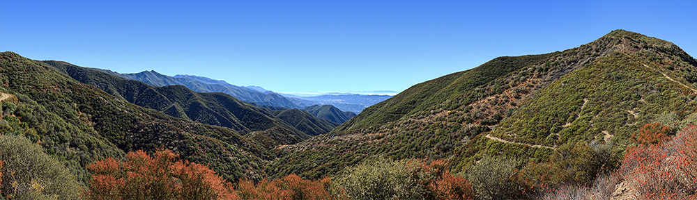
Beyond Chokecherry I engaged in a rewarding process of pedaling, observing and remembering. At one point I was startled by a large turkey vulture that launched from the east slope of the road and passed just a few feet above my head. I had never been buzzed by a turkey vulture before and considered, without coming to a conclusion, a number of anthropomorphic explanations. At the top of the last climb before the Big Pine – Sierra Madre FS road junction I stopped to look back.

Looking south from the crest of the last significant climb of the day near the 9N11 – 32S13 junction, May 16, 2013.
Back at the junction, I had one small mission yet to complete before the descent to my vehicle. The inspiration for the day was a ride in 1986 on the Big Pine road to the Judell Canyon Trail junction with the Sierra Madre road.

Judell Canyon trai sign at the junction with the Sierra Madre FS road, May 16, 2013.
As I sat by the Judell Canyon trail sign I remembered a solo backpack I took along the Sisquoc River in the later half of the 1980s. I started from Santa Barbara Canyon and descended to the Sisquoc via the Judell Canyon trail. That was the last time I passed by this sign. I could not remember the exact date but recalled it was noted in my 1981 Gagnon.

Exploring the Santa Barbara Backcountry, 1981, page 84
I find it interesting that Gagnon chose Lion Spring as the start point for Heath camp. I last visited the Lion Spring road head in the mid-1980s but no record of the hike I took to Painted Rock that day remains. Getting to Lion Spring meant negotiating an oil field road maze but I used to know the way. Now it is closed. That exceeds sad by several orders of magnitude as the routes to Salisbury Potrero or Painted Rock are spectacular.
I do not have pictures of the trip to the Sisquoc that started on April 25, 1987. I recall I lost the film I shot before I had a chance to have it developed. However, I still have some scraps of trail notes from that backpack.

Trail notes, April 25, 1987.
Evidently I encountered a rattlesnake 0.25 miles before Cottonwood camp. Some things never change in the Southern Los Padres. I don’t remember that encounter. I’m sure I was not referring to Rattlesnake Canyon or Creek as they are beyond Cottonwood in my direction of travel. I did note the Rattlesnake Canyon and Logan Canyon signs (there were wooden signs, maybe gone post Zaca fire) before reaching Mansfield camp. Note also the “overgrown” comments. Some things never change in the Southern Los Padres.

Rattlesnake near Happy Hunting Ground camp heading toward Manzana Narrows, March 26, 1988. Some things never change in the Southern Los Padres.

Rattlesnake near Reyes Peak trail head, August 19, 2011. One last time: some things never change in the Southern Los Padres.
I rode the short distance back to the 9N11 – 32S13 road junction and stopped to look north and absorb the Santa Barbara Potrero ambiance.

Santa Barbara Potrero
Finally, there was nothing left to do but descend the 1800 feet to the Big Pine road gate at Alamo Canyon, five miles distant. The air was cool, the disk brakes on the bike were powerful and I was at peace with the day.

Final descent to the Big Pine road gate, May 16, 2013.
The tale of the day in terms of linear measurement was 4,400 feet of climbing over twenty seven miles. In terms of temporal measurement, I reviewed twenty five years of previously unobserved change in six hours.

Ride route, May 16, 2013

Ride elevation profile, May 16, 2013.
Epilog
An illuminating benediction to end a story is a wonderful liturgical device. It can turn a mundane, wandering assemblage of random reflections as found in this tale into something approaching a parable. I am sure I do not achieve this laudable goal in any of my writing in this blog or anywhere else.
Nonetheless, this story does have somewhat of a moral; a lesson learned so to speak. If the thing you have to do next is not urgent and the thing you are doing presently is of great importance to you and going exceedingly well, forget the thing you have to do next and keep doing the thing you are doing.
I had perfect conditions on May 16, 2013 for the mountain bike ride on the Big Pine Forest Service Road. The weather was mild. I was fit for the task. The road went on from my turnaround point to more places I very much want to see again. I should have blown off my self-imposed commitments and kept riding while the riding was good.
Ultimately, fate has played a delayed trick on me. I will not be back nearly as soon as I would like. In 1983 I tripped in, of all places, Sespe Creek near Willet after hiking over the Red Reef trail. I cracked my left knee hard and hiked out that day and the next via Red Reef with my knee making an odd grinding sound. I visited a friend of mine who also happened to be an orthopedic surgeon. He listened to the knee and said, “what do you think that sound is.” My response was, of course, “you’re the orthopod, you tell me.”

Harris tunnel, Red Reef trail, April, 1983.
Over the years the knee has flared and been treated with anti-inflammatories via one method of administration or another. Finally, thirty years later, it was clear the time had come for more serious remediation. The MRI showed a significant tear in the medial meniscus where only a tiny nick had appeared previously. As as result, 60% of that medial meniscus was arthroscopically removed. I am now aggressively rehabiliting the knee but the timing of my return to full functionality is still an open question. But it will likely not be until some time well into in 2014. We’ll see.
On May 16, 2013, I should have continued riding.

60% of the medial meniscus of my left knee, July 25, 2013.
Pretty sure that missing photo is looking down into the Santa Barbara Canyon drainage with the Chumash far in the distance. Great writeup by the way.