It will still be a thirty-year anniversary trip if I do it before the end of March, 2014.
It is unquestionably preferable to have the time to create an equivalency between adventures held in imagination and adventures undertaken in reality. My imagination for my March, 2013 trip west to Ojai across three time zones was modest: perhaps a three day backpack somewhere in the Los Padres. Specifically, I wanted to visit Ladybug camp and the Sespe tracing the route I took in March, 1983, the last time I passed through the iconic Harris Tunnel on Red Reef trail. But this thirty-year anniversary high concept trip was not to be; as mentioned in the post Back to Matilija, 2013-03-17: the Murietta Five, my time was committed elsewhere.

Harris tunnel, Red Reef trail, March, 1983: not this trip, but eventually.
But I did have afternoons free and quick hikes from the Ojai Valley should not be undervalued. The alternative was remaining indoors engaging in a process of rapid attitude deterioration. This would serve no one particularly well. Not that I always need a goal (I don’t) but in this case I decided that the theme for the hikes would be “take the best possible pictures given the conditions.” I never presume that my photographic efforts will be worth viewing. Rather, I enjoy the challenge of setting up a shot and seeing what I can put together once I get back to my digital darkroom. In the face of obvious photographic failure, delete and forget is a viable and cost-effective strategy in the digital age.
I have presented previously in words and pictures (some images dating back to the late 1970s) my long association with the Horn Canyon trail, here and here. In the afternoon of March 18, 2013 I headed up the Horn Canyon trail to The Pines and carried my panorama kit with no particular agenda. When I arrived at The Pines there was no wind; I don’t remember ever seeing the camp so still. This made conditions perfect for shooting a stitched panorama of the camp without dealing with ghosting from subject movement which can be especially problematic with tree branches. Below is a two row by eight frame panorama. Each frame is a three shot high dynamic range composite.

The Pines camp panorama, Horn Canyon trail, March 18, 2013
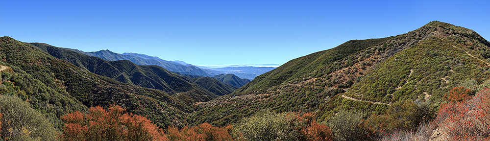
Early in the afternoon of March 19, 2013 I headed to the Oso trail head in Ojai for a quick hike up Kennedy Ridge in the Ventura River Preserve. About half way up the climb to Kennedy Ridge I crossed paths with an impressively large rattlesnake. He moved quickly across the the trail, evidently uninterested in posing for a potrait. When he departed the footpath I proceeded carefully while a warning rattle continued somewhere in the bush. Once on the ridge I hiked a short distance west to the distinctive rock outcropping I had visited previously under wet, soupy conditions to photograph a non-marine layer obscured version of the panorama I shot that wet day, December 16, 2012. The evolving story of Kennedy Ridge is covered in this post in the craigrcarey.net blog. I would also direct the reader to review the fine work of the Ojai Valley Land Conservancy.

Panorama of the Ventura River preserve from Kennedy Ridge, March 19, 2013.
In the late afternoon of March 20 I was again without pressing duties so I headed up Signal Street to the Pratt trail head. I had not been on the Pratt trail since shortly after the Wheeler Fire in 1985. I took no pictures in 1985, but I remember clearly the view from the sign in the picture below. The trail was not the well maintained tread portrayed in this image, it was an ankle-breaking obstacle course of rock fall. This day, I hiked as far as Valley View camp and returned to Ojai as twilight approached. Valley View camp is an interesting place. It is a shady location, cool even on this warm day and supplied with water from a spring, It has not the slightest view of any valley. The scholar of all things Los Padres and author of Hiking and Backpacking Santa Barbara and Ventura suggested to me that Valley View camp should be named after the legendary Ranger Boggs who did the work to revive the trail and build the camp sometime after the Wheeler Fire. I heartily agree. I generally speak with Ranger Boggs when I am in Ojai, but I have not yet suggested this to him. I suspect he will find the concept puzzling, such is his low key modesty. But it should be done. And with that pronouncement I will close the written portion of this missive.

The start of the upper portion of the Pratt trail, March 20, 2013; shortly after the Wheeler Fire in 1985 this was an ankle-breaking rockfall obstacle course.

The Ojai Valley from the Pratt trail, March 20, 2013

Valley View camp, March 20, 2013

Water from the spring at Valley View camp

The Ojai Valley, Lake Casitas and the Channel Islands at twilight, March 20, 2013
In 1970 with Boy Scouts, I hiked to ‘The Pines’ from Lions Camp in Rose Valley; we were well prepared for rain, especially after the training “flood fun of 69”. It drizzled all day of hiking; but suddenly cleared off late afternoon. To us boys, The Pines was an idyllic welcome sight, along with a beautiful, bright Ojai sunset after a cold wet day of bushwhacking. …. After shooing the cattle away; we had the camp all to ourselves; and as a bonus, the cattle left behind plenty of ammo for our beloved ‘meadow wafer’ fights!…
(Also This where I learned that wet leather boots will grow hairy mold inside and out, in a mere eight hours of slumber.)
We hiked down to Thatcher School on a very hot Sunday; & I believe there was a rattlesnake somewhere in our journey too.
Fast forward….Marsha and our son Lucas visited The Pines in 1985; everything looked the same as 1970 and your current photos show not much has changed in 43 years.
Eldon; Thanks For Sharing your adventures……
Would you be interested in sharing a high res version of your
“Ojai Valley, Lake Casitas and the Channel Islands at twilight, March 20, 2013”
photo for use in the Ventura River Watershed Management Plan and on the website?
Have you taken any photos of drainages in the Ventura River watershed this month (August 2013). I’m compiling images for a photo essay on the watershed in its drier times.
Thanks.
Lorraine Walter
Ventura River Watershed Coordinator