Gridley Trail to Nordhoff Peak, May 1, 2012:
Sometimes the best approach is to accept the default.
A long time ago I needed to run a program that implemented an algorithm for a particular type of data analysis that was fairly new at the time. For the computer historians the system was a VAX 11/785 running 4.2 BSD Unix. I obtained a copy of the code and somehow got it to compile and all seemed well to that point. As with many programs of the era, upon execution this one read a command file full of directives in some arcane format that set all the required runtime parameters. I opened the command file in my old friend, the text editor vi, and did not understand most of the hundreds of lines of configuration details. I contacted the author and received advice that I have found useful in many areas of life, “The best approach is to accept the defaults.”

Line printer output circa 1985. I do not remember what W=f(t) defined, why the INT function was called nor the basis for the 0.25 second measurement interval.
One might reasonably wonder how the above vignette relates to the subject of this post. Elsewhere in this blog I have described how, after more than twenty years of intense, dedicated Los Padres hiking and backpacking, circumstances conspired to enforce a twenty year period of Los Padres inactivity. As is often the case, the term “inactivity” is an approximate descriptor of reality but does not wholly encapsulate the truth. I still had roots in Ventura County and returned to Ojai on a semi-regular basis that normalized to at least once a year. Usually pressed for time, I tried nonetheless to escape for a hike while in town. Given its ease of access and my historical fondness for the hike as way to walk in mountains without having to think much while realizing a useful training effect, the Gridley trail became the default.
After a perfect three-day trip into the Chumash Wilderness April 28 to April 30, 2012 with the author of Hiking and Backpacking the Santa Barbara and Ventura and the RSO, I found myself at loose ends on May 1. Not wanting to waste a perfectly good hiking day in Ojai I considered my options. I had to get an early start the next day to catch a plane at LAX for points east so complicated logistics for the hike seemed out of bounds. But I still wanted a hike of some significance. Then it occurred to me: accept the default. The Gridley trail was, as a reasonable first approximation, just around the corner. And what the hell, I hadn’t been to the Nordhoff fire lookout since 1984. For a history of the Nordhoff lookout, please refer to the always outstanding work at craigrcarey.net by the author of Hiking and Backpacking Santa Barbara and Ventura (Yes, I linked it twice in one paragraph; it is that important. So, dear reader, if you haven’t obtained your copy, stop reading this drivel and take care of business. The Web and this blog will be here when you get back.).
I had hiked from the Gridley trail head to the Nordhoff fire road in 2005 as a warm-up to a hiking vacation in BIg Sur and again in 2010 during a stop in Ojai after a few days of hiking and photography in Mineral King in the Sierra Nevada. I don’t remember much of the 2005 hike other than firing off a few pro forma frames after reaching the fire road. For the 2010 hike I had a self-assigned specific mission to shoot panoramic photos where the Gridley trail ended on the ridge. Beyond that, on those hikes I simply put my head out of gear and walked, noticing little along the way. This day, in keeping with the Los Padres Expatriate theme, I committed to paying attention, taking sufficient documentary photographs and comparing what I observed to old memories and whatever old photographs I could disinter from my archives.

Chief Peak, Topatopa Bluff from Gridley trail terminus on Nordhoff Ridge, November 15, 2005.

View toward the Topatopa Bluff near the terminus of the Gridley trail on Nordhoff Ridge, May 1, 2012.

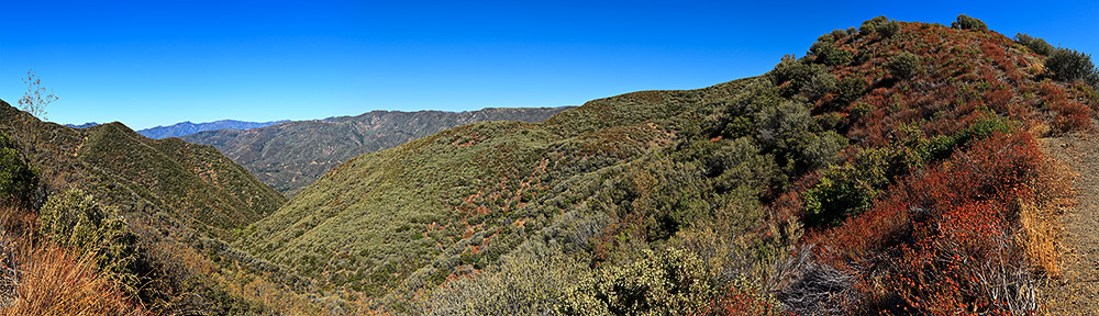
Panorama south from Gridley trail terminus on Nordhoff Ridge, September 13, 2010.

Panorama north from Gridley Trail terminus on Nordhoff Ridge, September 13, 2010.
I have hiked Gridley in a wide variety of weather conditions over the years: extreme heat, pleasantly moderate, cold, clear skies, cloudy skies, rain, snow. On this iteration of the eternal Gridley, I was starting in a heavy marine layer. If I could get above it or if it partially burned off, the result could be fairly dramatic skies for photography. Of course, another possibility was heavy mist with no visibility all the way. This is why I find outdoor adventure so compelling; even within the familiar boundaries of the “Gridley default” there was a seed of randomness that added an element of unpredicability.
I followed the familiar route from the trail head sign to the dirt Gridley Road that runs through the avocado trees. Because I was paying attention this day it quickly became quite clear to me that the Forest Service (no doubt acting as proxy for the land owners) truly, sincerely wants you, the hiker, to stay on the approved route. I don’t recall this as a particular problem that required such aggressive signage, but point taken. I made a point to find the old metal sign that marked the junction of the trail with the dirt road and warned hikers to take the trail and not contravene the private property beyond the sign. Clearly, this sign has been superseded by the new, uninspired, arrow-on-stake signs and stands as a relic of an earlier stage in sign evolution; an atavism, if you will, but paradoxically an expression of the devolution of the art of the trail sign (a relic of a time when signs were signs and not devolved arrows-on-stakes).

Gridley trail head, May 1, 2012.

I infer from this proliferation of trail markers that one should endeavor to stay on the trail. I get it, I really do. May 1, 2012.

This is signage that existed through the (I believe) mid-1980s. This shot is from 1979.

I found this sign obscured behind some brush. This old school torch cut sign was the functional marker of the point where the trail to Gridley Road left the dirt road through the avocado trees to bypass the private property below. May 1, 2012.
As I walked along the avocado tree-lined dirt road I reflected on Boots, my Pit Bull – Great Dane hiking companion of the early to mid-1980s and her proclivity to poach downed fruit. As long as the avocados she consumed were taken from the road I figured some rule of legitimate salvage must apply. Beyond that, I was reasonably sure that avocado rustling was then, and likely still is, a hanging offense in California and monitored Boots accordingly.

Boots, 1984
I quickly arrived at Gridley Springs camp and carefully considered the changes. The site has been reconfigured greatly from flooding and subsequent human modification since the 1970s and early 1980s. There used to be a camp sign, stove and picnic table on the west side of the road / trail on the south side of the outflow from the spring. The water trough was on the north side of the outflow and the hitching post was located at the bend in the trail just beyond camp heading north (uphill). Some of the detritus of the old camp is visible but might not be recognized as such if one had never seen the camp in days past. It never occurred to me to document this photographically as it was, after all, only Gridley Springs camp, hardly an exotic location. I hope I have acquired the wisdom not to engage in such poor thinking in the ensuing years.

The view up the outlet of Gridley Spring in fog, May 1, 2012. Some concrete slabs that provided anchors for the components of the old camp can be seen protruding from the ground just right of center. The trough was located at the position of the concrete slabs and the stove and picnic table were located picture left.

The watering trough used to sit more or less where the concrete footings in the picture above are located. May 1, 2012.

Gridley Camp and hitching post, May 1, 2012. The hitching post was located in the bend in road beyond camp heading uphill. This fire ring / grill did not exist in the 1970s and 1980s; there was a stove / grill and picnic table as described in the shot above of the outlet of Gridley Springs.
As I ascended above Gridley Springs the marine layer did not let up; in fact, if anything, it deepened. I did note the obvious evidence of enthusiasm with which some mountain bikers approach the descent of this section of the route.

Some mountain bikes go wide here, others ride the high bank well above the trail bed after, I presume, gathering some serious downhill speed. This is a two shot stitched panorama of about 50 yards of trail. May 1, 2012.
I recalled how one would hike the winding route uphill and suddenly, as it seemed, round a switchback and see the sign at the terminus of the Gridley trail on the Nordhoff Fire Road. Today, the effect was more nuanced as the sign gradually materialized into view through the heavy fog.

The Gridley Trail sign fades in through the mist, May 1, 2012.
I stood on the road in the heavy mist gazing at the sign. I was troubled by a vague existential dissonance. And realized quite suddenly the source. This sign was not the sign I remembered. The sign I remembered had two sides. Someone had written a paean to a dog named Cindy on that sign describing how, at ten, she was still eager to hike the Gridley trail. Although such graffiti violates my sense of wilderness anti-defacement orthodoxy, the piece was so well written that I granted it an internal orthodoxy exception.
 and north (bottom frame) sides.")
Gridley Trail sign at Nordhoff ridge, south (top frame) and north (bottom frame) sides. December, 1984.

Gridley Trail sign at Nordhoff ridge, May 1, 2012.The sign is now single (north)-sided. Note the updated mileage information.
I had not bothered to review the hike at all beforehand so I had quite forgotten that the mile along the road to the Nordhoff Peak Fire Lookout gains almost 800 feet. As this mile is along a wide road and is well graded, the elevation gain is only marginally perceptible. As I walked along the road alone shrouded in the heavy marine layer I considered the years 1969 to1989 when I hiked the Los Padres on a near continuous basis. Then I was gone for twenty years with only this default hike interrupting that absence from time to time. Now I had begun a concerted effort to return to my old haunts. “Haunts” – an interesting word and concept. Were I given to such flights of self indulgent fancy I might have considered myself this day a ghost in the Los Padres mists. But I am sure that would only serve, in an imaginary world, to anger some ancient Chumash spirit. In the world of Newtonian physics I was just a hiker walking a route, subject to vector forces of gravity, and that is good enough for me.

Telephoto view of Topatopa Bluff from the approach to Nordhoff Peak, December, 1984

View toward Topatopa Bluff approaching Nordhoff Peak, May 1, 2012
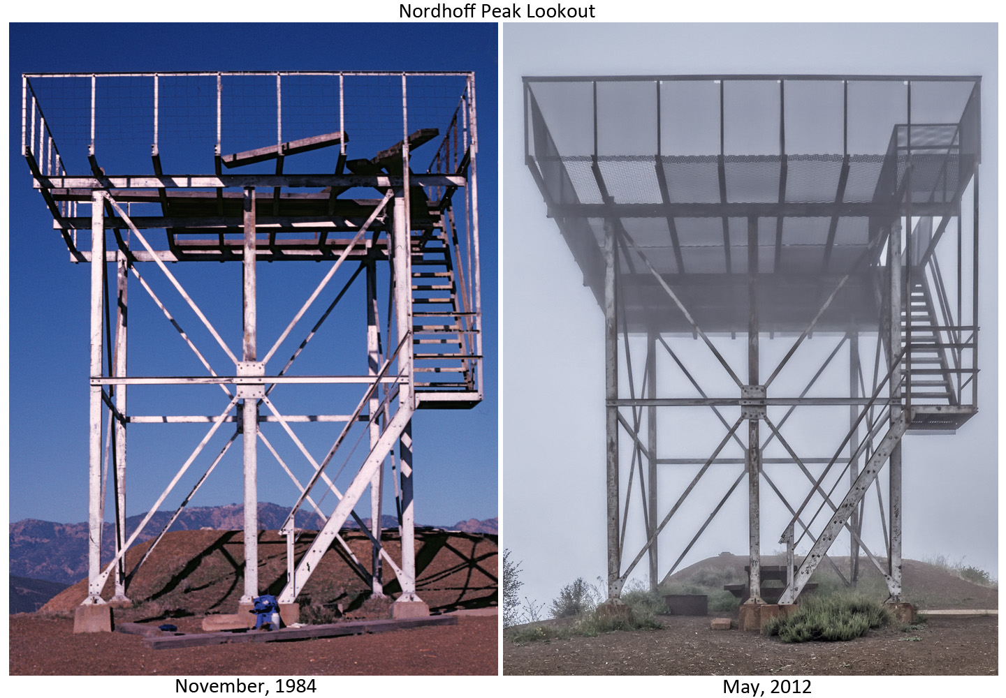
Finally I reached Nordhoff Peak and the Nordhoff Fire Tower. To my surprise some obvious renovations had been made to the tower itself and a picnic table and fire pit had been added. My hope for panoramic photos and shots of the Topatopa Bluff from Nordhoff Peak were thwarted by the fog. In fact, an accurate term for the conditions is “light drizzle.” I deployed camera and tripod and did what I could photographically, given that I had hauled this gear the seven miles over an elevation gain of 3900 feet as reported by my GPS. Then I started the long drop back to Gridley Road. Someday, before too long I suppose, I will find myself in Ojai with no better plan than to once again accept the default and head to Gridley. Some photographs need to be taken on a day with useful visibility.

View toward the Pacific Ocean from Nordhoff Peak, December, 1984.

View toward the Pacific Ocean from Nordhoff Peak, May 1, 2012.

December, 1984; a study in the optical physics of lens flare.
Ghost in the Los Padres mist, May 1, 2012.
Expat, I was unaware of Gridley Springs’s original placement; thanks for that piece of intel. (I always though the current spot was a sorry choice; this sheds some light on placement post-Wheeler Incident.) The Gridley photos are fantastic.